


 24/7 Emergency Service
Weather Alert
1/2/2018 (Permalink)
Winter Weather Alert
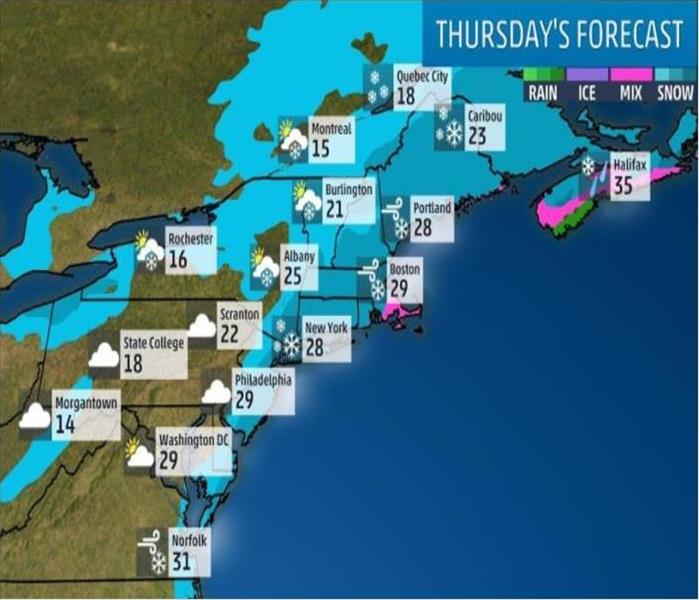
The temperatures outside in New England are devastating. Now it looks like we may add snow and strong winds to the mix! The Eastern Seaboard will likely experience 4-8 inches of snow and strong winds this Thursday (Jan 4, 2018) the magnitude of both those impacts is still a bit uncertain at this time.
Timing
Thursday-Thursday night
- The powerful storm will be centered well off the Northeast coast. Given its large circulation and strong intensity, the low will likely produce at least some snowfall, possibly heavy, in parts of the Northeast region.
- Snowfall may cover much of New England during the day.
- Due to the strong winds this will be a fast moving storm. The peak snowfall intensity will likely only last for about 6 hours, between noon and 6 p.m.
- Increasing winds are likely along much of the Northeast coast. Wind gusts stronger than 50 mph are possible along the immediate coasts of New England Thursday night.
Snow Potential
- The best chance for significant accumulating snow along the U.S. coast is in eastern New England. This snow may be heavy and accompanied by strong winds.
- Again, exact amounts will depend on the track of the low in relation to the East Coast.
- Some locations may experience heavy snow that may change to freezing rain in Thursday night into Friday.